Crashes, No Sound, or Screen Glitches?
Random freezes, missing sound and display glitches usually trace back to one bad driver. Find and replace yours safely.Free scan · under a minutePC Slower Than It Used to Be?
A free scan shows the junk files, broken settings and background clutter dragging Windows down - then fixes them in one click.Free scan · Windows 10 & 11AGCO announced a partnership with agricultural technology company AgIntegrated (AGI) on May 30, 2018, to help move agronomic data between AGCO equipment and farm-management information systems (FMIS). The announcement named TaskDoc Pro, VarioDoc Pro, and Go-Task as possible wireless transfer routes, depending on machine brand and model. It described plans to launch services in North America that year; it does not confirm that the specific OnSite QC Pro connection is available today.
What the AGCO–AgIntegrated partnership was intended to do
AGCO presented the development partnership as a way to connect customers with agronomy service providers and make it easier to transfer agronomic data between farm equipment and a customer’s preferred partners. AgIntegrated’s OnSite QC Pro was described as a data hub for connecting technologies, rather than requiring a separate communication path for each one. AGCO’s May 30, 2018 announcement said customers could access the ecosystem through a direct connection or by downloading and uploading data.
The release described services as launching in North America in 2018. That was an announcement-era plan, not confirmation of current regional availability or support.
How data transfer was described
The announcement named three possible wireless routes: TaskDoc Pro, VarioDoc Pro, and Go-Task. Which route applied depended on the equipment brand and model; it did not say that every AGCO machine supported all three.
Quick wins for a faster PC:
Repair Windows errors before they cause bigger problemsFix Now →Scan for outdated or missing drivers - takes under a minuteDriver Scan →Clear out junk files and repair common Windows errorsFree Scan →#1 Best Overall
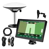
- Complete Tractor Guidance System: Includes stable software to guide tractor along AB lines, featuring a 7 inch waterproof navigator display with high-precision GNSS Board, high precision GNSS GPS Antenna, and all necessary accessories cables and tools
- Smart GNSS Guidance & AB Line Planning: Generates straight AB lines or curve paths based on your field boundary and working width, records driving tracks and provides real-time deviation alerts to keep passes straight at night or in low visibility conditions
- Multi-Frequency Positioning (L1L5): Large 7 inch screen displays guidance lines, field boundaries, and tractor position in real time. The L1L5 multi-frequency module delivers higher accuracy and more stable signals than single-frequency GPS, keeping every pass on track even near trees or buildings. The device needs to be connected to either a cell phone hotspot or a personal mobile network
- Wide Application Compatibility: Tractor GPS navigation system can be widely used for sowing, cultivating, trenching, ridging, spraying pesticide, transplanting, land consolidation, harvesting and other work scenes. Suitable for John Deere, Case IH, New Holland, Massey Ferguson, Fendt, Kubota, and most tractors. Suction-cup tablet bracket mounts on cab window with no drilling required. Swap between machines in approximately 3 minutes
- Google Maps & 48 Languages: Built on Google Maps for use in most regions worldwide, suitable for international farms or contractors. 48 language options let operators work in their native language, reducing training time and errors
AGCO advised customers to ask their FMIS provider which connection options were available. In practical terms, the FMIS—the system used to manage farm information and workflows—was part of the compatibility picture, alongside the machine and its transfer option. The release did not provide a full technical specification, a complete FMIS list, or a current compatibility chart.
What formats and data types were mentioned
In the 2018 release, AgIntegrated’s then-vice president of Business Development, Mike Santostefano, said the connection could translate and support AGCO XML prescription and as-applied, planted, and harvest data file formats. This describes the capability the companies announced at the time; it is not a present-day file-format specification or confirmation that the connection remains supported.
Rank #2

- SMART GNSS GUIDANCE & AB LINE PLANNING – Set your field boundary and working width, then let the system generate guidance lines, record driving tracks, and show real-time deviation alerts. Helps you keep straighter passes, reduce overlaps and skips, and work with more confidence in large fields
- MULTI-GNSS, MULTI-FREQUENCY POSITIONING – Supports GPS, GLONASS, GALILEO, and BDS for stable satellite positioning in field operations. The large 9-inch display shows guidance lines, field boundaries, tractor position, and route direction clearly at a glance
- SAVE FIELDS & TRACKS FOR REUSE – Record, name, save, and recall multiple fields and task routes for repeat seasonal work. Easily return to previous field boundaries and guidance tracks for plowing, seeding, spraying, fertilizing, mowing, and other field tasks
- FAST SETUP & WIDE TRACTOR COMPATIBILITY – Designed for most tractors with a suitable metal mounting surface and cab window. The magnetic GNSS antenna mounts outside, while the suction-cup monitor bracket attaches inside the cab with no drilling required. Set up in about 3 minutes and move between machines when needed
- BUILT FOR REAL FARM CONDITIONS – The outdoor GNSS antenna is built to handle rain, dust, mud, and tough field environments, while the monitor stays protected inside the tractor cab. Clear on-screen guidance helps operators stay on track during long working days and low-visibility conditions
Is the connection available today?
The available current AGCO material describes a broader PTx precision-ag portfolio and current TaskDoc and FarmENGAGE workflows, but does not establish continuity of the specific AgIntegrated OnSite QC Pro integration. AGCO’s PTx announcement, its connected-data information, and its TaskDoc information provide present-day context, not proof that the 2018 connection is still active. An earlier 2019 Esri–AgIntegrated partnership announcement describes Onsite API Services/QC Pro as a hub for data from multiple equipment sources; it likewise does not verify current AGCO compatibility.
Before relying on this route for a purchase or an operating workflow, ask AGCO, AgIntegrated, and the relevant FMIS provider to confirm:
Rank #3
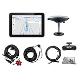
- What is it: JY100 Plus Tractor guidance system with stable software to guidance tractor go along with AB line. includes a 10inch water proof android tablet integrated with a high-precision GNSS Board, and a high precision 601A GNSS GPS Antenna and accessories cables and tools, precision AG software included permanently valid
- How to work:This JY100 Plus tractor GPS navigation system is integrated with farming tractor navigation software, guide tractor go along with straight navigation or Curve under Setting AB line accordingly work for high precision agriculture. Four steps to start guidance for farming:1.Connect GNSS Antenna to ANT1 port and install on central AXIS of tractor. 2. Turn off autosteering 3. Select correct Antenna:T101 single antenna 4.Create A-B line to start
- Where to use: JY100 Plus Tractor GPS navigation system can be widely used for sowing, cultivating, trenching, ridging,spraying pesticide,transplanting,land consolidation, harvesting and other work scenes. It is suitable for various applications of tractors, harvesting machines, trees planting, rice transplanters,and other agricultural implepment
- Why to use: JY100 Plus Tractor guidance system stable, Easy to install. Compatible with any brand and any model of tractor. works in any country. Greatly improved farming accuracy and efficiency
- Supports multiple constellations & frequencies: GPS L1, L2 GLONASS L1, L2 BeiDou B1,B2,B3 . Multiple languages supported, Map-based navigation,Task Controller functionality via Setting A-B for straight navigation,curve navigation or history path navigation
- Whether the exact OnSite QC Pro connection is currently supported, in your region.
- Which equipment brand, model, and software versions are compatible.
- Whether your intended data can move in the required direction, including prescriptions and as-applied, planting, or harvest records.
- Whether the workflow uses a direct cloud connection or requires downloading and uploading files.
- Which FMIS and agronomy-provider connections are currently supported, and who provides service support.
What the announcement does not establish
AGCO described intended benefits such as easier connections and digitized farm operations, but the announcement reported no measured yield gains, time savings, adoption rate, or number of compatible FMIS platforms. It also said AgIntegrated had 15 years in the precision-ag industry; that was a company-history statement included by AGCO in 2018, not an independent performance measure.
AGCO’s announcement is the primary source for the partnership’s date, scope, named transfer routes, and conditional compatibility. Successful Farming’s same-day report also described the conditional FMIS options.
Quick Recap
Best Value

- 2.5cm Accuracy: Correction sources by RTK Base SMA26 Pro or CORS give the JY305 Plus autosteering system an accuracy of 2.5 cm. Please purchase the JY305 Plus+SMA26 Pro RTK base bundle if you do not have CORS. Otherwise, it operates in PPP mode with an accuracy of 10 cm and above. There is no need for additional networks subscriptions or charges when using SMA26 Pro RTK BASE or PPP
- Necessary Parts: 1)Included extra and built-in gyroscope: Single or double gyro mode both work with the JY305 Plus gps system for tractor 2) Included type A spline with 36 teeth and a diameter of 21.3-21.7 mm, which is compatible for New Holland and John Deere. Free additional spline from SMAJAYU is available to fit kinds of brand tractor
- Software and Support: 1) The tablet integrated with the JY305 Plus tractor GPS Auto Steer System supports multiple languages: English, Spanish, French, etc., and supports various constellations and frequencies. It supports farm surveying and farm management. Field area and speed can be viewed on the display screen. It supports importing A-B lines. 2) It supports installation manuals, video training, and remote diagnostics
- Package Inclusions: 10-inch waterproof tablet with a high-precision GNSS board, a high-torque auto steering motor with an integrated controller,a high-precision GNSS GPS receiver, a extra gyroscope and additional cables and tools. Weight:20kg/set, Size: 67.5*48.5*26.8cm/set
- Working Instructions and Uses: On a farm, this JY305 tractor auto steering system can steering on its own which reduces labor investment, increases farmer productivity and makes farming more intelligent for sowing, cultivating, trenching, ridging, spraying, transplanting, consolidating land, harvesting, and other tasks. It can be used with a wide range of tractors, harvesting equipment, rice transplanters, plant protection equipment, and other agricultural implement
Rank #4

- High-Resolution Display: 7-inch (17.8 cm) capacitive touchscreen display provides clear visibility and responsive touch control
- Simplified Guidance Controls: Create, swap, rename, and manage guidance lines all in one widget, making in-job adjustments easier
- Auto Field Boundaries: Keep you organized effortlessly with automatic field boundary detection and management
- Slingshot Connectivity: Ready for file transfer and remote support through Slingshot integration
- Enhanced Performance: Features 2x the processing power and 4x as much memory compared to legacy CR7, with faster boot times averaging 20 seconds
Product prices and availability are accurate as of the date/time indicated and are subject to change. Any price and availability information displayed on Amazon at the time of purchase will apply.




