Before you buy, assess the exact address for flood, heat, and earthquake exposure, then investigate how the building and unit would fare and what the remaining risk could cost. Hazard maps are screening tools—not safety certifications. This guide uses U.S. federal guidance; buyers elsewhere should consult the equivalent local agencies and rules.
Start with the exact property and jurisdiction
First clarify whether you are buying a unit in the high-rise or a separate property nearby. A map can help describe hazards around either location, but a unit’s floor, orientation, access, utilities, and building systems affect what an event could mean for you. A nearby building may have different construction, elevation, and protections from the tower next door.
Confirm the street address, municipality or county, parcel, building name, unit, and ownership type. Local hazard layers, building records, disclosure rules, and codes vary. Treat third-party risk summaries as leads and verify important findings with official sources. The Consumer Financial Protection Bureau (CFPB) cautions that it does not guarantee the accuracy of nongovernment risk websites.
Screen each hazard, then investigate the building
Flood: check the map, local history, and vulnerable systems
Search the address in the Federal Emergency Management Agency’s (FEMA) Flood Map Service Center. Review the latest available map and any flood-zone or base-flood-elevation information shown. FEMA identifies the Service Center as the source for its latest available flood maps and address searches. Then ask the local floodplain manager about local flood history and records.
What’s actually slowing this PC down?
Pick the symptom - the matching free tool is one click away.
#1 Best Overall

- [Color LCD Screen Weather Station] Newentor temperature & humidity monitor with a large color LCD display shows essential home weather information at a glance: indoor/outdoor temperature & humidity, daily high/low records, customizable alerts, time/date, alarm clock & snooze, weather forecast, moon phase, and barometric pressure.
- [Two Power Modes & Adjustable Backlight] To enjoy a 24/7 continuous always-on vibrant display, simply connect this home weather station to a wall outlet using the included DC power adapter. When operating on battery power only (batteries not included), the digital thermometer automatically enters an eco-energy-saving mode, where the screen lights up for a quick 15-second glance before dimming. It is the perfect bedside or living room clock designed to fit your power preference.
- [3-channel Home Weather Stations Wireless Indoor Outdoor] Wireless temperature forecast station supports up to 3 remote sensors to monitor inside outside temperature & humidity of multiple locations. Package contains one remote sensor.
- [Wireless Forecast Station] The weather forecast station calculates the weather forecast for the next 12-24 hours, 7 to 10 days calibration ensures an accurate personal forecast for your location.
- [Wireless Weather Station with Atomic Time&Date] Atomic alarm clock weather station can be used not only as a wireless indoor outdoor thermometer but also as an atomic clock with dual alarms.
A mapped designation is not a guarantee about a particular property, and being outside a Special Flood Hazard Area (SFHA) does not mean flooding is impossible. The CFPB reports that an SFHA has at least a one-in-four chance of flooding over a 30-year mortgage; that is a broad area-level characterization, not a forecast for a specific building. The CFPB also notes that flooding occurs outside designated SFHAs.
Ask the seller or property manager which areas have flooded, which systems were affected, what repairs were completed, and whether claims or disaster assistance occurred. In a high-rise, ask specifically about parking, entrances, elevators, utility rooms, and critical equipment. These questions help identify potential consequences; a map alone cannot establish whether those systems are protected.
Ask the local floodplain manager whether an elevation certificate is available. The National Flood Insurance Program (NFIP) says the certificate documents building characteristics, including first-floor height, and helps insurers assess risk. It may identify discounts but does not set the insurance rate. If one is needed, a surveyor, engineer, or architect may prepare it.
Rank #2

- COMPLETE WEATHER STATION: (1) Osprey Sensor Array with Rain Cup, and (1) Brilliant, Easy-to-Read LCD Color Display
- AUTHENTIC HYPER-LOCAL DATA: Monitor your actual home and backyard weather conditions with our wireless and Wi-Fi-enabled sensor array measuring wind speed/direction, temperature, humidity, rainfall, UV intensity, and solar radiation
- SMART HOME READY: Set up alerts, access your data remotely, and program your home based on weather conditions using IFTT, Google Home, Alexa, and more
- ENHANCED WIFI: Enables your station to transmit its data wirelessly to the world's largest personal weather station network (optional setting)
- JOIN THE COMMUNITY: Connect to Ambient Weather Network to customize your dashboard tiles, share hyperlocal weather conditions via social feeds and create your own forecasts (coming soon)
Heat: distinguish neighborhood conditions from indoor comfort
Look for local heat-risk or urban-heat information at the block or neighborhood scale, then assess the actual property. Relevant features include orientation, direct sun, shade, nearby pavement and roofs, vegetation, ventilation, cooling equipment, and utility costs. Ask about hot-season comfort and outages; review energy bills and building-system records if available.
Recommended Free Tools
Air temperature and surface temperature answer different questions. The U.S. Environmental Protection Agency (EPA) explains that air temperatures better reflect conditions people experience, while surface measurements can reveal fine-scale differences among roofs, pavement, and grass. Satellite surface-temperature data alone do not establish the air temperature—or comfort—inside a particular unit. EPA’s “Measuring Heat Islands” guidance says combining satellite surface data with air-temperature monitoring or traverses offers the most complete picture of a city’s heat island.
Earthquake: use regional hazard maps as a screen, not a building verdict
Use applicable U.S. Geological Survey (USGS) seismic hazard maps or model information to understand regional shaking potential. The USGS National Seismic Hazard Model map description includes a map showing a 2 percent probability of exceedance in 50 years for ground acceleration at a firm-rock site. That probability level describes the map’s shaking measure; it is not the probability that a specific building will be damaged.
Rank #3
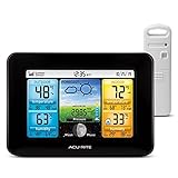
- Simple Setup and Use: Install 2 AA batteries (not included) in the outdoor weather station sensor and easily hang on a post or tree branch using the integrated hanger to begin receiving your weather forecast and hyperlocal conditions
- Real-Time Weather Conditions: This indoor outdoor weather station has an indoor temperature gauge and an outdoor temperature thermometer for indoor and outdoor temperature, humidity, and barometric pressure trends from an outdoor temperature sensor
- Weather Forecast and Forecasting Technology: The outside temperature thermometer wirelessly relays data to provide a hyperlocal, personalized weather forecast 12 hours from your current conditions, so you can plan your la crosse or other sports game!
- Illuminated LCD Color Display: Easy-to-view digital indoor outdoor thermometer display has an adjustable dimmer to make for the perfect addition to your home technology and allows easy placement anywhere in the house, office, or as an RV weather station
- Dynamic Forecast Icons and Moon Phase: With multiple thermometers & weather instruments data, this digital indoor outdoor thermometer display has trend arrows and provides the current moon phase to further impact your weather monitoring capabilities
Local geology can amplify ground motion, and a regional map cannot tell you how a particular structure will perform. Ask for the construction year, structural system, engineering or retrofit reports, permits, code-related records, and records of earthquake damage or repairs. For site-specific questions, consult an appropriately licensed structural or geotechnical professional. The USGS says individual site studies must be arranged privately and warns that published maps provide generalized, uninterpreted information about specific areas.
Request records and verify repairs
Ask for seller disclosures, repair invoices, engineering reports, building inspection records, mitigation documentation, and relevant association or property-management records. Request insurance-claim or disaster-assistance history where available. The CFPB recommends asking about past disaster damage and repairs, then having an inspector examine the repairs. Disclosure requirements and access to records vary by state and locality.
Give dated documents more weight than verbal assurances. Check whether a report covers the specific building and unit, what areas were inspected, and whether later repairs or alterations are documented. If records are missing or a repair is material to your decision, ask an independent inspector or relevant specialist to evaluate it.
Rank #4

- Comprehensive Weather Information: One of the best weather stations, receive over 55 data points that allow you to monitor historical data, the heat index, dew point, feels like temperature, pressure trends with trend arrow, and more
- Real-Time Weather Conditions: Look no further for the perfect indoor and outdoor weather station! Wirelessly receive readings for indoor/outdoor temperature and humidity, wind speed/direction, barometric pressure, and rainfall directly to your home weather station
- Easiest Setup on the Market: Just install batteries, attach the wireless outdoor sensor to a pole or post using the included mounting bracket, and you’re ready to be the neighborhood weather expert
- Weather Clock: The indoor weather station display is a large, color LCD Display with the current time, date, and an adjustable dimmer, making it convenient to read and easily view indoor and outdoor data, time, and conditions
- Weather Forecast: The outdoor weather station collects elevation data and combines it with barometric pressure data from the indoor weather station to provide a personalized weather forecast 12 hours from your current conditions
Compare candidate properties on evidence and consequences
| Comparison area | Evidence to record for each property |
|---|---|
| Flood | Official map designation and elevation information; local flood history; exposure of entrances, parking, and critical equipment; available flood coverage and quoted terms. |
| Heat | Local heat patterns; shade and surrounding surfaces; orientation, floor, and window exposure; cooling-system condition and operating cost. |
| Earthquake | Regional shaking hazard; site geology; structural system; construction and retrofit records; need for independent review. |
| Evidence quality | Official maps and records, dated reports, permits, disclosures, and documented repairs versus unsupported assurances. |
| Financial resilience | Insurance terms, deductibles and exclusions; likely repair or mitigation needs; potential assessments and disruption costs. |
Use the same questions for every candidate. A property with more documented mitigation or better records may be easier to evaluate, but documentation does not itself guarantee low risk.
Independent reader supportYour contribution helps us test, update, and keep practical guides available for everyone.Price the remaining risk before making an offer
Get insurance quotes for your intended ownership and mortgage arrangement rather than relying on the seller’s current premium. Compare coverage limits, deductibles, exclusions, and whether separate flood or earthquake coverage is available. Standard homeowners insurance typically does not cover flood damage. A government-backed mortgage on a property in a designated SFHA generally requires flood insurance; confirm the specific lender and property requirements. A new owner may face a different risk-based premium, so an existing policy’s cost may not carry over.
Ask the lender and insurer what documents they require. Consider not only premiums but also out-of-pocket costs, possible repairs or mitigation, and disruption if access or building systems are affected. The CFPB reports that owners of high-risk properties can have difficulty finding affordable private coverage. An affordable quote is not proof of structural safety; unusually costly or unavailable coverage warrants closer investigation of both the property and the local insurance market.
Best Value

- Illuminated Indoor Outdoor Weather Station for Home with Large Colorful Display: The home weather station delivers large big numbers for weather forecast info, indoor outdoor temperature, atomic time, date, year and calendar day, which is super easy to read from afar.
- Indoor outdoor Thermometer Wireless with High/Low Temperature Alert: The digital weather station supports 3 outdoor sensors which helps to monitor temperature and humidity of multiple locations (one sensor included). With the high/low temperature alert function, the weather station clock keeps you informed about the changes of weather thermometer outdoor.
- WWVB Atomic Weather Station with Auto DST: Weather atomic clock with indoor/outdoor temp always keeps precise time and date by receiving the WWVB atomic signal. The self setting digital weather clock will automatically adjust to daylight saving time with auto DST feature, no more resetting twice a year.
- Personal Weather Forecast Station: This weather stations wireless indoor outdoor predicts the next 12-24 hours weather condition with a 7-day calibration through the pressure of your location which provides you a better outing experience.
- 5 Level Adjustable Backlight Brightness: The weather clock indoor outdoor temperature atomic with backlight dimmer function helps you avoid high-intensity light that disturb your sleep and easily check the weather situation during the day.
Protect the decision with inspections and contingencies
Where local law and transaction practice allow, consider an inspection contingency and time for specialist review. Ask your inspector to examine documented disaster repairs. If earthquake-related site conditions matter, check state authorities’ professional licensing and certification requirements; for an elevation certificate, start with the local floodplain manager and consult a qualified surveyor, engineer, or architect if needed.
These steps can help you compare exposure, building vulnerability, and financial consequences, but they cannot establish the safety of a particular property without its records and appropriate on-site assessment. The cited federal guidance is U.S.-based and does not determine local rules or conditions for a specific address.
Quick Recap
Product prices and availability are accurate as of the date/time indicated and are subject to change. Any price and availability information displayed on Amazon at the time of purchase will apply.




