The Tool Desk
Outbyte PC Repair FREERepair Windows errors before they cause bigger problemsFix Now →Outbyte Driver Updater FREEFix the driver behind crashes, sound loss and screen glitchesFind Drivers →Matter Intelligence emerged from stealth on October 30, 2024, announcing a $12 million seed round led by Lowercarbon Capital, with Toyota Ventures, Pear, Mark Cuban and E2MC participating. The California startup says it is developing satellites and airborne systems that combine hyperspectral, thermal and conventional imaging with machine learning. A 2025 U.S. Department of Defense SBIR award shows that an airborne demonstrator is being developed, but publicly available evidence does not establish that Matter’s planned EARTH-1 satellite had launched by August 18, 2026.
For readers evaluating the business rather than the headline, the distinction matters: the financing and government award are real milestones, while the company’s largest performance and commercialization claims remain future-oriented.


What Matter Intelligence announced
According to Matter’s company announcement distributed through Business Wire, the company raised $12 million in seed funding and left stealth on October 30, 2024. Lowercarbon Capital led the round; Toyota Ventures, Pear, Mark Cuban and E2MC also participated. Fenwick separately confirmed its work on the financing in its transaction announcement.
Matter said it would use the money to develop sensing infrastructure, build the company and expand customer engagement. The release described a founding team with experience connected to NASA’s Jet Propulsion Laboratory, Caltech, Mars missions and spaceborne imaging. Those credentials indicate relevant technical experience, but they are not independent validation of Matter’s future spacecraft or commercial service.
Quick wins for a faster PC:
Clear out junk files and repair common Windows errorsFree Scan →Fix the driver behind crashes, sound loss and screen glitchesFind Drivers →Repair Windows errors before they cause bigger problemsFix Now →#1 Best Overall
The announcement identified the first planned satellite as EARTH-1 and said a launch date would be announced later. No public evidence in the available sources confirms an orbital launch, operating constellation, customer revenue or a public imagery catalog.
What the technology is supposed to do
From color to material signatures
RGB cameras record visible red, green and blue light. Multispectral instruments measure a limited set of broader spectral bands, often chosen for tasks such as vegetation analysis. Hyperspectral instruments divide a much wider range into many narrow bands. Those bands can reveal reflectance patterns associated with minerals, vegetation stress, moisture and other surface properties that may look identical in an ordinary photograph.
Thermal imaging adds information related to emitted heat. Matter’s proposed stack combines conventional visual context, hyperspectral signatures and thermal measurements, then applies machine-learning models to interpret the data. The company’s website now describes this approach as “ultraspectral” sensing paired with a foundational model or “Large World Model” intended to help machines understand physical materials. Its current positioning covers satellites, infrastructure, robotics and industrial uses; the site offers early access rather than self-serve purchasing.
“Molecular-level understanding” is company positioning, not a claim that a satellite performs laboratory molecular analysis in every situation. Remote instruments infer material properties from measured signatures. Results depend on illumination, atmospheric correction, calibration, spatial resolution, signal-to-noise ratio, target size, spectral libraries and model quality. Detection, classification, quantification and definitive identification are different levels of confidence.
Rank #2
EARTH-1 and the newer EARTH-a demonstration
EARTH-1: the planned orbital system
Matter’s 2024 release described EARTH-1 as a planned sub-meter hyperspectral and thermal satellite intended to build a global material-composition dataset. The company said it wanted to map mineral composition, vegetation health and atmospheric conditions. It also claimed that the system could provide more than 500 times the “information density” of existing sensors.
That 500-times figure must be treated as a Matter-defined comparison. “Information density” is not a universal metric equivalent to resolution, accuracy, revisit rate, bandwidth or data volume. The release does not provide the baseline sensor, spectral range, band count, signal-to-noise assumptions or calculation needed to reproduce it.
EARTH-a: an airborne risk-reduction step
A 2025 Department of the Air Force SBIR record describes EARTH-a, an airborne demonstration intended to validate an integrated sensor before deployment on EARTH-1. The award record describes:
- High-resolution panchromatic, hyperspectral and thermal-infrared imaging.
- More than 2,000 bands spanning ultraviolet through thermal-infrared in the described architecture.
- An airborne spatial-resolution target of less than 50 centimeters.
- Thermal sensitivity of less than 100 millikelvin.
- Onboard processing using an NVIDIA AGX Orin processor.
- Georeferenced RGB and hyperspectral products, thermal heatmaps and LiDAR-like surface-elevation models.
The record lists a $1,248,445 Direct-to-Phase-II SBIR award to Matter Intelligence, Inc. This is meaningful evidence of government-supported development and a proposed demonstration—not proof that the complete orbital system has flown, met every specification in space or produced commercial data. The SBIR description referred to EARTH-1 launching in 2026, but a launch confirmation and orbital status are not established in the available material as of August 18, 2026.
Free tools Windows power users keep installed
One-click scans. No signup required.
Where Matter says the platform could be used
Matter’s applications page lists industries including mining, agriculture, emissions monitoring, insurance, defense, carbon measurement, utilities, environmental compliance, urban planning and robotics. Each use case requires a different combination of spectral detail, spatial resolution, revisit frequency and latency.
Mining and critical minerals
Hyperspectral signatures can help screen for mineralogical differences and prioritize field sampling. A useful mining product still needs suitable resolution, atmospheric correction, geological ground truth and confirmation through drilling or laboratory analysis. A satellite indication is not, by itself, a reserve estimate.
Agriculture
Reflectance and thermal changes may support crop-stress, nutrient or disease monitoring. Cloud cover, crop stage, irrigation, soil background and field-level calibration can materially affect results. Farmers and agronomists also need recommendations delivered at the right time, not merely a dense data cube.
Emissions and climate monitoring
Spectral instruments may detect methane or other emissions under favorable conditions. Wind, plume dispersion, cloud, viewing geometry and detection thresholds determine whether a signal can be attributed and quantified. “Invisible to traditional optical sensors” does not mean visible through all clouds, foliage or structures.
Rank #4
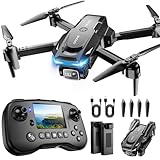
- The PK01 drone's remote comes with a super handy built-in screen—no phone needed—so you can watch live HD footage and check flight stats right in your hands. (An SD card is required to save images and videos; not included) Powered by tough brushless motors, this little flyer is strong, smooth, and built to last. With one-key takeoff/landing, headless mode, and even 360° flips, you’ll look like a pro in no time. Ready for takeoff?🤩
- 📷【Drone with Camera】 Equipped with a 1080P HD 80°adjustable lens, the drone not only assists you in catching every wonderful moment from a bird's-eye perspective but is also perfect for selfies. It can even be used to check the roof of a house or other hard-to-reach areas. You can enjoy the real-time HD pictures and videos via the remote screen & APP. Automatically take photos/videos with gestures. First flight tip: choose a windless indoor space, keep the altitude below 6 meters and the distance below 30 meters to help better practice and control the drone.
- 🕹️【More Fun to Fly】 This foldable drone has 2 control modes: remote control, APP control. You can enjoy exciting features such as one-click 360° flips, 3D flip, waypoint flyflight, gravity control, circle fly, rotation fly, 3 speed gear, gravity sensing and Emergency Stop. (Some functions should be controlled by the app) You can also effortlessly command the remote control drone with simple voice instructions like "Take off"and more.
- 🔋【Long Flying Time and Safer】 The upgraded FPV drone is equipped with two enhanced batteries, extending the flight time to 25 minutes, providing no-worry flying experience. The controller has built-in battery and comes with 2pcs USB charging cable, enables you to charge it effortlessly. Features with emergency stop, 4 propeller guards, child lock feature and low power alarm to ensure a safe and reliable flight. PK01 is lightweight, portable and No FAA Registration needed, makes it a ideal drone for indoor and outdoor activities.
- 📲【How to Connect Your Phone】1.Power off the remote controller. 2. Turn on the drone. Note: Make sure the tail of the drone is facing towards you. 3. Download and log in to the "PK01 DRONE" app. 4. Connect your phone to the Wi-Fi network named "PK01DRONE_XXXXXX" via the app. 5. Move the left and right joysticks of the remote control to the lower left or lower right 45 degrees at the same time. The drone light flashes and then turns on, completing horizontal calibration. 6. Enter the app control interface, tap the "Control Switch" icon, and then select "Take Off" for a successful launch.
Insurance and infrastructure
Thermal and spectral information could support roof-material classification, wildfire and flood-risk assessment, occupancy indicators or utility inspection. Insurers would still need property records, claims data, weather information and validation before using outputs in underwriting or parametric payouts.
Defense, intelligence and robotics
Matter lists target recognition, military-asset detection and machine perception among potential applications. These markets add requirements involving latency, security, export controls, privacy and reliability. Commercial and defense priorities may pull the product toward different coverage, processing and delivery models.
Independent reader supportYour contribution helps us test, update, and keep practical guides available for everyone.Why the engineering claims are difficult
Spectral richness creates a data problem
Thousands of bands produce far more data than RGB or ordinary multispectral imaging. Spacecraft must manage detector calibration, storage, compression, power, onboard computing and downlink capacity. Matter’s emphasis on edge processing addresses part of that problem, but complete spacecraft bandwidth, storage, compression and downlink specifications have not been publicly disclosed.
Resolution, swath and revisit are a trade-off
Sub-meter imaging over a broad area requires compromises involving optics, detector size, orbit, power and swath width. A satellite can deliver very fine detail over a narrow strip while revisiting less often, or cover more ground at lower resolution. “Global encyclopedia” and “real-time” are strategic goals until Matter publishes operational coverage, revisit and latency figures.
What’s actually slowing this PC down?
Pick the symptom - the matching free tool is one click away.
Passive optical sensing has environmental limits
Clouds, haze, atmospheric absorption, shadows, sun angle and surface moisture can degrade hyperspectral observations. Thermal channels require their own calibration and atmospheric correction. A strong sensor cannot remove missing photons or guarantee a clean measurement in every weather condition.
Models require ground truth
Useful outputs depend on field measurements, laboratory samples, property records, weather data and other reference sets. Spectral signatures can overlap, and mixed pixels, dust, moisture, coatings, camouflage, weathering and viewing angle can confuse a classifier. A proprietary foundation model may be valuable, but training and validating one at global scale requires expensive, carefully labeled data.
What the funding does—and does not—tell investors
A $12 million seed round gives Matter capital to develop hardware, software, testing and customer pilots. It does not disclose a valuation, ownership dilution, revenue, burn rate or remaining runway. The company is private, and the announcement does not create a public stock or a normal retail-investing opportunity.
The SBIR award adds non-dilutive government support for the EARTH-a demonstration, but it also signals that the technology is still moving through development and validation. Hardware startups must finance spacecraft engineering, launch, calibration, ground infrastructure, data processing, sales and customer qualification at the same time.
As of the available company materials, Matter has not published a public price list, subscription plan, API catalog, service-level agreement, customer list or independent benchmark. Its website uses an early-access and contact-led model. That may suit defense, mining or industrial pilot programs, but it is not the same as an immediately purchasable imagery service.
How Matter compares with available sensing options
| Option | Typical strength | When it may fit better than an unlaunched Matter service |
|---|---|---|
| Conventional high-resolution optical imagery | Established visual detail and broad workflows | Organizations needing proven imagery and straightforward mapping |
| Multispectral constellations | Repeat monitoring at scale | Users prioritizing coverage and revisit over very dense spectral data |
| Commercial hyperspectral providers | Material-oriented analysis | Customers needing hyperspectral data now; examples include Kuva Space and Pixxel |
| Airborne or drone hyperspectral surveys | Targeted, high-resolution collection | Projects that can arrange a flight over a limited area immediately |
| SAR and RF sensing | Different all-weather and surface-structure information | Applications where clouds or nighttime conditions make passive optical data unsuitable |
| Established optical providers | Operational archives, tasking and geospatial services | Customers seeking mature commercial workflows from providers such as Planet, Vantor or Satellogic |
These are category comparisons, not claims that any alternative offers Matter’s proposed combination of spectral, thermal, edge-computing and AI capabilities. Commercial pricing is generally quote-based, and no comparable rate should be inferred without a specific proposal.
What to watch next
- Documented completion and results from the EARTH-a airborne demonstration.
- A confirmed EARTH-1 launch, orbital commissioning and publicly described operating parameters.
- Independent measurements of spatial resolution, spectral performance, thermal sensitivity and geolocation accuracy.
- Evidence of paying customers, repeat contracts, data delivery and application-level validation.
- Published coverage, revisit, latency, pricing and access terms for the early-access service.
Matter has a credible technical ambition, meaningful seed backing and a government-supported path to test its integrated sensor. The evidence supports calling it a serious development-stage remote-sensing company. It does not yet support treating the company as a functioning global real-time constellation or assuming that the “500 times” claim represents a standardized performance advantage.
Quick Recap
Product prices and availability are accurate as of the date/time indicated and are subject to change. Any price and availability information displayed on Amazon at the time of purchase will apply.
Recommended Free Tools