
A phone cannot simply switch from a cell tower to any satellite. Direct satellite connectivity works only on compatible models, in supported countries, with the manufacturer’s supported software and carrier conditions. In practice, an iPhone 14 or later can use Emergency SOS via satellite and, where offered, satellite messages, roadside assistance and Find My location sharing. Google’s Satellite SOS works on Pixel 9-series phones except Pixel 9a in listed locations. For regular two-way messaging, tracking and a separate SOS device, a communicator such as the Garmin inReach Mini 2 is the more capable option, but it requires an active satellite subscription.
The safest approach is to check eligibility before leaving coverage, prepare the emergency settings, and treat satellite messaging as a slow, low-bandwidth link rather than a replacement for cellular service.
As an Amazon Associate I earn from qualifying purchases.
What “connecting a phone to a satellite” actually means
When a phone is off the cellular grid, it normally has no route for calls, texts or data. A supported satellite feature adds a direct radio link from the handset to satellites, then through the provider’s ground network to emergency responders or messaging services. It does not make every app work offline and it does not turn an ordinary phone into a satellite internet terminal.
Eligibility is controlled by several factors at once:
#1 Best Overall

- Bundle Includes: Garmin inReach Mini 2 Satellite Communicator With GPS (Flame Red) + 10ft USB Type A to USB Type C Cable - Black + USB Charging Adapters + USB Car adapter + 6Ave Microfiber Cleaning Cloth + P-Bank Portable Battery Charger
- Interactive SOS Alerts: InReach Mini 2 features in emergencies, trigger an SOS to the Garmin Response coordination center, staffed 24/7, for prompt support and coordination of your rescue. Flexible Satellite Airtime Plans Offers both annual contracts and month-to-month plans, making it easy to choose a satellite subscription that suits your needs. Control your inReach Mini 2 ly via compatible Garmin handhelds, wearables, or mobile devices for added convenience and versatility.
- Compact and Rugged Design: Garmin Inreach Mini 2- Satellite communicator small size (4” x 2”, weighing 3.5 oz), it's built tough (MIL-STD-810) and water-resistant (IPX7), designed to withstand the elements. Up to 14 days of battery life in the default 10-minute tracking mode, extending up to 30 days on a 30-minute tracking interval, supporting longer adventures. Access detailed weather updates directly on your device or a paired device, ensuring you stay ahead of changing conditions.
- TracBack Routing: Inreach mini 2 satellite communicator Features Trackback Routing, If you lose your way, it helps navigate you back to your starting point using the same route you came. Easily share your journey location with loved ones via your Garmin MapShare page or embed your coordinates in messages, so friends and family can follow your adventures in real time. In addition, Digital Compass Provides accurate heading information even when stationary, enhancing navigation capabilities.
- Global Satellite Coverage: Inreach Garmin Mini 2 Utilizes the Iridium satellite network for global coverage, ensuring you stay connected in areas where cell phones can't. Garmin Mini 2 Satellite communicator enables two-way messaging and interactive SOS globally, Send and receive text messages or emails with anyone, anywhere, even without cell coverage. You can also post to social media or communicate directly from inReach to inReach in the field.
- Phone model: The feature may be limited to a particular generation or variant.
- Software: The required operating-system version and messaging app must be installed.
- Country and carrier: Satellite services are enabled only in listed regions and can be subject to carrier or government conditions.
- Use case: Emergency SOS, ordinary personal messages, location sharing and roadside assistance are separate capabilities.
- Sky view: The handset needs a usable path to the sky; buildings, terrain and vegetation can interrupt it.
Check all five before treating the feature as part of your emergency plan. A phone that displays a satellite setting in one country may not offer the same setting after you cross a border.
Phone-native options at a glance
| Device or route | Satellite functions described by the manufacturer | Important conditions |
|---|---|---|
| iPhone 14 or later | Emergency SOS via satellite; in supported regions, Messages via satellite, roadside assistance and Find My location sharing | Supported region, current iOS, clear view of sky and horizon; availability varies by feature |
| Pixel 9-series phone, except Pixel 9a | Google Satellite SOS | Listed country, compatible carrier and government conditions, Google Messages as the default messaging app, clear sky view |
| Phone paired with Garmin inReach Mini 2 | Two-way text, tracking, weather and interactive SOS through Garmin Response | Separate communicator, Bluetooth pairing and an active satellite subscription |
Prepare before you leave cellular coverage
Satellite functions are easiest to use when they have already been enabled and tested at home. Complete this checklist while you still have reliable service.
- Confirm the exact model. Check the model name in your phone’s settings or on its purchase record. “iPhone” or “Pixel” alone is not enough: iPhone satellite features begin with iPhone 14, and Pixel Satellite SOS excludes Pixel 9a.
- Update the operating system. Install the latest available iOS or Android update for the device. Restart afterward and verify that the satellite option still appears.
- Check country and carrier eligibility. Read the manufacturer’s current availability list for every country on the trip. Pixel availability covers the United States, Canada, Puerto Rico and specified European and other countries, but the list is subject to carrier and government conditions. Apple’s satellite features are also regional and feature-specific.
- Set up emergency information. On an iPhone, complete Medical ID and add emergency contacts. On a Pixel, decide which contacts should be notified when Satellite SOS offers that choice. Keep the information current, especially allergies, medications and a reachable contact number.
- Run the built-in demonstration. Where the setting is available, use the iPhone satellite demo before departure. A demonstration teaches the direction prompts without creating an emergency case.
- Prepare any communicator. If you are taking an inReach Mini 2, activate its satellite plan, charge it, pair it with the Garmin Messenger app over Bluetooth and send a test message while you still have time to correct setup problems. The communicator supplies the satellite link; the phone supplies the larger keyboard and display.
- Tell someone your plan. Give a trusted person your route, expected check-in times and the device you will carry. Satellite SOS is not a substitute for a trip plan.
- Protect power and access. Carry the phone where you can reach it quickly, keep it charged, and keep the communicator’s controls usable. A phone inside a pack or behind dense material is harder to position when a connection prompt appears.
How to use an iPhone when there is no cellular service
iPhone satellite tools have different workflows for emergencies and ordinary communication. Do not use an ordinary message workflow to report an immediate danger.
Rank #2

- Easy to use
- Good product for use
- Good performance
- Good quality
Emergency SOS via satellite
- Try the local emergency number first. Place the emergency call normally. If the call cannot connect because mobile and other available networks are out of reach, the iPhone can offer the satellite emergency workflow.
- Select “Emergency Text via Satellite.” Follow the on-screen instructions rather than opening a normal text conversation.
- Complete the questionnaire. Answer the prompts about what happened, your location and the assistance required. The answers help responders understand the situation when voice calling is unavailable.
- Go outdoors. Apple’s guidance is to “Be outside with a clear view of the sky and the horizon.” Dense trees, cliffs, buildings and other obstructions can prevent a link.
- Follow the positioning arrows. Hold the iPhone naturally in your hand and turn left or right as the screen directs. Apple says you do not need to raise your arm or hold the phone overhead.
- Remain available for replies. Satellite messages can take time to travel. Keep following the positioning instructions and watch for questions or responses from emergency services.
The emergency workflow is intended for situations that need responders. It is not a faster route to ordinary texting, and it should not be used to test the service in a non-emergency.
Messages via satellite for non-emergency communication
Where Apple enables Messages via satellite, open Messages while you are off-grid and follow the prompt to connect to a satellite. The phone will guide you to a usable position. This is for short personal messages in supported regions; it does not mean that every iMessage feature, attachment or app will work without a cellular or Wi-Fi connection.
Satellite messaging is deliberately narrow-bandwidth. Keep the message concise, allow extra time for delivery, and avoid assuming that a recipient’s reply will arrive immediately. If the message is urgent or life-threatening, use Emergency SOS rather than ordinary Messages.
Rank #3

- Lightweight SOS satellite communicator uses the global Iridium satellite network so you can stay connected without cell coverage (active satellite subscription required; some jurisdictions regulate or prohibit the use of satellite communication devices)
- Explore with peace of mind knowing you can trigger an interactive SOS message with location coordinates to Garmin Response℠, a 24/7-staffed international coordination center, for help in an emergency (active satellite subscription required; some jurisdictions regulate or prohibit the use of satellite communication devices)
- Exchange photos, texts and voice messages without cell service; taking and sending photos requires pairing your inReach device with your compatible smartphone by using the Garmin Messenger app (active satellite subscription required; some jurisdictions regulate or prohibit the use of satellite communication devices)
- Rugged design features a high-resolution and scratch-resistant color touchscreen; can withstand impact, extreme weather and harsh temperatures (IP67 water rating)
- Internal, rechargeable lithium battery supports up to 350 hours with 10-minute inReach tracking and up to 95 hours in performance messaging mode
Find My and roadside assistance
In regions where Apple offers them, Find My location sharing and roadside assistance use the same general satellite-positioning principle but are separate from Emergency SOS. Availability depends on the country and the specific service. Confirm those features before travel instead of assuming that access to Emergency SOS includes every other satellite function.
Recommended Free Tools
How to use Satellite SOS on a supported Pixel
Google’s Satellite SOS is available on Pixel 9-series phones except Pixel 9a in listed countries. Google Messages must be the default messaging app. The exact country list and carrier requirements can change, so check them before departure.
- Dial the local emergency number. Start with a normal emergency call.
- Wait for the satellite option if no network is available. When the phone has neither mobile nor Wi-Fi service, select Satellite SOS.
- Tap “Use Satellite SOS,” then “Start.” The phone opens the satellite emergency flow.
- Complete the emergency questionnaire. Provide the requested details so responders receive useful context.
- Choose whether to notify contacts. If the option appears, select the people who should receive the emergency notification.
- Follow the positioning prompts. Move as the phone directs until it establishes the satellite link.
- Stay outside with a clear sky view. Remain in position to receive replies and additional questions.
A Pixel’s satellite option can disappear when you travel outside an eligible area, use an unsupported carrier or use a model such as Pixel 9a. Those are eligibility issues, not necessarily hardware failures.
Rank #4

- Lightweight SOS satellite communicator uses the global Iridium satellite network so you can stay connected without cell coverage (active satellite subscription required; some jurisdictions regulate or prohibit the use of satellite communication devices)
- Explore with peace of mind knowing you can trigger an interactive SOS message with location coordinates to Garmin Response℠, a 24/7-staffed international coordination center, for help in an emergency (active satellite subscription required; some jurisdictions regulate or prohibit the use of satellite communication devices)
- Exchange text messages without cell service (active satellite subscription required; some jurisdictions regulate or prohibit the use of satellite communication devices)
- Rugged design features a high-resolution and scratch-resistant color touchscreen; can withstand impact, extreme weather and harsh temperatures (IP67 water rating)
- Internal, rechargeable lithium battery supports up to 350 hours with 10-minute inReach tracking and provides safety charging to help restore a depleted phone
When a dedicated communicator is the better choice
A phone’s built-in satellite function is useful when you need an emergency link or occasional messages and already own a compatible handset. A dedicated communicator is designed for repeated off-grid contact.
What the inReach Mini 2 adds
Garmin describes LTE phones as dependent on a ground-based network of cell towers, while inReach uses the Iridium satellite network. The inReach Mini 2 supports two-way text messaging, tracking, weather information and interactive SOS through Garmin Response. It can pair by Bluetooth with the Garmin Messenger app, allowing your phone to provide the keyboard and display while the communicator provides the satellite connection.
Free tools Windows power users keep installed
One-click scans. No signup required.
An active satellite subscription is required. Plan terms can vary, so check the current plan for your region before purchasing or budgeting for a trip. Without an active plan, the communicator is not a functioning substitute for cellular service.
Best Value
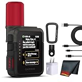
- Bundle Includes: Garmin inReach Mini 3 Plus compact SOS Satellite Communicator + Microfiber Cleaning Cloth + Generic Brand 10ft USB Type A to USB Type C cable - Black + USB Wall Charger
- GLOBAL MESSAGING AND MEDIA SHARING: Stay connected outside cell coverage using the Iridium satellite network and exchange texts, voice messages, and group messages directly from the device. When paired with your compatible smartphone, you can capture and send photos through the Garmin Messenger app. Designed for hikers and workers who need dependable communication and the ability to share updates from isolated environments.
- INTERACTIVE SOS AND REAL-TIME COORDINATION: Trigger an interactive SOS alert to Garmin Response, a 24/7 staffed emergency coordination center that receives your location and maintains two-way communication during a crisis. Ideal for travelers, backcountry explorers, and field professionals who require a dependable tool for emergency support in regions where traditional communication methods are unavailable.
- RUGGED TOUCHSCREEN DESIGN AND EXTENDED BATTERY: Built with a scratch-resistant color touchscreen and IP67-rated durability, the inReach Mini 3 Plus handles impact, severe weather, and demanding terrain. The internal rechargeable battery delivers up to 350 hours with 10-minute tracking or up to 95 hours in performance messaging mode, providing long-lasting operation during multi-day trips without frequent recharging.
- ADVANCED APP INTEGRATION AND LOCATION SHARING: Pair with the Garmin Messenger and Garmin Explore apps for optimized messaging, trip planning, weather forecasts, and LiveTrack location sharing that displays distance, time, and elevation. Voice commands support hands-free check-ins and tracking, and preset messages allow quick updates without using your monthly text allotment, keeping communication efficient and reliable.
Practical setup and use
- Activate the subscription before departure. Complete account and emergency-contact details while you have internet access.
- Pair the devices. Connect the inReach Mini 2 to the Garmin Messenger app over Bluetooth and verify that the app can see the communicator.
- Test a two-way exchange. Send a short message and confirm that a reply arrives. This checks account status, Bluetooth pairing and the intended recipient.
- Set tracking expectations. Tell contacts how often you plan to send tracking updates; tracking uses battery and subscription resources.
- Carry the communicator where it can see the sky. The phone can remain in hand for typing, but the inReach itself needs a usable satellite view.
- Use interactive SOS for emergencies. Follow the device’s SOS process and continue responding to Garmin Response requests.
The main advantage is independence: if your phone battery fails, breaks or is not a supported model, the communicator remains a separate satellite device. The trade-off is carrying another device and paying for an active plan.
Independent reader supportYour contribution helps us test, update, and keep practical guides available for everyone.Phone satellite features versus a dedicated communicator
| Question | Compatible phone feature | Dedicated communicator |
|---|---|---|
| Eligibility | Exact model, software, country and carrier conditions | Compatible communicator, account and active satellite plan |
| Primary purpose | Emergency responder contact; in some regions, occasional messages, roadside assistance or location sharing | Regular two-way messaging, tracking, weather and interactive SOS |
| Separate hardware | No; the phone is the satellite device | Yes; the inReach supplies the satellite radio and can use the phone as an interface |
| Subscription | Terms can be introductory or regional and depend on the manufacturer and feature | Active Garmin satellite subscription required |
| Environmental requirement | Best outdoors with a clear sky and horizon | Best with the communicator positioned for a clear sky view |
| Typical communication pattern | Emergency workflow or occasional short messages where enabled | Ongoing conversations and scheduled tracking |
Why a satellite connection can be slow or fail
Satellite messaging is sensitive to what lies between the antenna and the sky. Apple reports that, in ideal conditions, a message may take 30 seconds or more. Under light or medium foliage, delivery can take several minutes. Dense foliage, hills, mountains, canyons and tall structures may block the connection entirely.
- Move to open ground. A clearing, ridge or unobstructed area is preferable to a forest interior, narrow canyon or spot beside a high building.
- Keep the horizon visible. A small patch of sky directly overhead may not be enough if the phone’s prompts indicate a different direction.
- Follow the arrows instead of guessing. Turn left or right exactly as the handset requests.
- Keep the device out of a pocket or backpack during the connection. Hold the phone naturally in your hand; do not assume that raising it above your head improves the link.
- Allow for delay. A message that has not appeared instantly may still be progressing. Repeatedly cancelling and restarting can make a slow exchange take longer.
- Consider latitude and regional limits. Satellite availability and service coverage can vary by location, even when the phone model is supported.
These constraints are normal characteristics of a low-bandwidth satellite link. They are not evidence that the phone has ordinary internet access through space.
Troubleshooting by symptom
There is no satellite option
- Verify the model: iPhone 14 or later for Apple’s phone satellite features; Pixel 9-series except Pixel 9a for Google Satellite SOS.
- Install the required operating-system update and restart the phone.
- Check that your current country and carrier are on the manufacturer’s availability list.
- For Pixel, confirm that Google Messages is the default messaging app.
- For ordinary iPhone messages, confirm that Messages via satellite is offered in that region; Emergency SOS availability does not automatically include every other feature.
The phone cannot establish a link
- Walk away from dense foliage, a mountainside, canyon walls and tall structures.
- Stand outside with a broad view of the sky and horizon.
- Hold the phone in your hand and follow the left-right positioning prompts.
- Wait through the indicated connection period before trying again.
A message is still pending
Expect at least 30 seconds in ideal conditions and several minutes under light or medium foliage, according to Apple’s guidance. Stay outdoors, maintain the prompted orientation and avoid treating a delay as a failed emergency until the phone reports that the attempt ended.
No reply arrives
Check that you used the correct workflow. Emergency situations belong in Emergency SOS or Satellite SOS, not an ordinary message thread. If you are in an emergency, remain outside, monitor the device for responder questions and keep the phone powered while the exchange continues.
Choosing the right approach for your trip
| Your situation | Most suitable approach | Reason |
|---|---|---|
| Rare backcountry travel with a compatible iPhone or Pixel | Prepare the phone-native satellite feature | No separate device is needed for supported emergency use, but eligibility and sky visibility still apply |
| Occasional non-emergency check-ins where phone messaging is enabled | Use the supported phone messaging feature | It can handle short personal messages without adding a communicator, with regional limits and delays |
| Frequent trips requiring scheduled tracking | Use a dedicated communicator such as inReach Mini 2 | Tracking, two-way messaging and interactive SOS are designed for recurring off-grid contact |
| Need a separate device in case the phone is damaged or out of power | Carry a dedicated communicator | The communicator has its own satellite radio and can use the phone only as an interface |
For any option, make the decision before leaving coverage. Confirm the device, region, software, emergency contacts, subscription status where applicable and the route’s likely sky visibility. A satellite feature is valuable only when the hardware is eligible, the service is available and you can position the device to reach the sky.
Quick Recap
Safety and planning rules to remember
- Call the local emergency number first whenever a normal call may work.
- Use Emergency SOS or Satellite SOS for emergencies; reserve ordinary satellite messages for non-emergency communication.
- Do not promise contacts instant delivery. Satellite messages can take 30 seconds or more in ideal conditions and several minutes with light or medium foliage.
- Keep a written route and check-in plan in addition to electronic tracking.
- Verify regional availability before crossing borders or relying on a feature for a remote expedition.
- If using an inReach Mini 2, keep the satellite subscription active for the entire period in which you expect to need service.
Product prices and availability are accurate as of the date/time indicated and are subject to change. Any price and availability information displayed on Amazon at the time of purchase will apply.
What’s actually slowing this PC down?
Pick the symptom - the matching free tool is one click away.




