Do these 3 things before closing this tab:
1Fix the driver behind crashes, sound loss and screen glitches2Repair Windows errors before they cause bigger problems3Scan for outdated or missing drivers - takes under a minuteSome links on this page are affiliate links: if you buy through them we may earn a commission, at no extra cost to you.
Seattle construction-technology company TraceAir announced a $25 million Series B on May 29, 2024. PeakSpan Capital led the round, joined by Flashpoint Venture Capital and existing investors. TraceAir said it would use the financing to develop and commercialize predictive-analytics products spanning land acquisition, planning and construction management—not merely to add another progress-photo feature.
The date matters: TraceAir later published a related page in 2026, but that page refers to the 2024 financing. This is not a new August 2026 funding event. The original announcement was issued May 29, 2024.
What TraceAir raised and who invested
The financing was a Series B led by PeakSpan Capital. Flashpoint Venture Capital and existing TraceAir investors also participated, although the announcement does not identify every existing investor that joined this specific round.
Recommended Free Tools
| Detail | Reported information |
|---|---|
| Round | Series B |
| Amount | $25 million |
| Announcement date | May 29, 2024 |
| Lead investor | PeakSpan Capital |
| Named participating investor | Flashpoint Venture Capital |
| Total funding after the round | Approximately $36 million, according to GeekWire |
TraceAir was founded in 2015 and is headquartered in Seattle, according to GeekWire. The publication identified Maria Khokhlova, Dmitry Korolev, Alexander Solovyev and Nikita Ushakov as founders, with Korolev serving as CEO.
#1 Best Overall

- SELF LEVELING ROTARY LASER: Designed for grading, excavating and general construction projects, the Topcon RL-H5A self-leveling laser can cover a 2,600-feet (800-meter) diameter job site with a high accuracy of 1/16 inch at 100 feet.
- LASER LEVEL KIT includes the RL-H5A laser, LS-80 laser receiver, sensor holder, durable carry case and EDEN Field Book. The Topcon laser level offers up to 100 hours of battery life.
- EASY TO USE: With electronic self-leveling, simply press the power button and start working. If the RL-H5A gets disturbed on the job, the H. I. alert will signal the laser receiver of the elevation change. Self-leveling range is ±5 degrees of level.
- IP66 WEATHERPROOF RATING: Designed to be drop-, dust-, and water-resistant, the RL-H5A leveling laser is "job site tough" and can withstand dust, a sudden shower and even torrential rainfall.
- BUILT FOR THE REAL WORLD: Established in 1932 and manufactured in Japan for over 90 years, Topcon surveying equipment positions people and equipment for projects across the globe. Our technology is assembled in the United States for quality you can trust.
An earlier TraceAir announcement described a $3.5 million Series A and $7 million raised at that point, alongside investors including XTX Ventures, Liquid 2 Ventures, GEM Capital, GPS Ventures and Metropolis VC. That history does not establish that every one of those investors participated in the Series B.
What TraceAir’s software does
TraceAir positions its product as site-intelligence and construction-automation software for homebuilders, land developers, grading contractors and related development teams. Its workflow combines drone capture, 3D site data and browser-based analysis.
Rank #2

- 360-Degree Rotating Scan: Self-leveling rotary laser level for efficient site-wide leveling and alignment. ±5° self-leveling with manual mode. Variable speeds (0/60/120/300/600 rpm) and scan angles (0°,10°,45°,90°,180°) cover every task. Laser Class:Class 2 (IEC/EN60825-1/2014), power output:<5mW
- 984 ft Working Distance: The laser level reaches up to 984 ft with the receiver, ideal for large remodels and small jobsites. Includes receiver, grade rod, tripod, and laser glasses to enhance visibility in bright conditions
- Rechargeable Power: Driven by four 1.2V NiMH cells, the rotary laser runs 8–12 hours per charge (charger included), keeping you productive without frequent battery swaps
- IP54 Durability: Rugged, impact-resistant housing seals out water and dirt for long-term reliability. The rotary laser level kit comes with a tough hard case for organized transport
- Effortless to Use: Intuitive interface plus remote control (up to 65 ft) for quick setup. 5/8 inch mounting thread fits most tripods and accessories used with rotary lasers
- Capture: Drones collect aerial imagery and site measurements.
- Model: TraceAir processes the data into maps, terrain information and 3D project views.
- Compare: Teams compare current conditions with design surfaces, grading plans and other approved project information.
- Manage: Users monitor progress, inspect earthwork, analyze cut and fill, evaluate site balance and coordinate work remotely.
- Document: Time-stamped records preserve site history for accountability, turnover, warranty questions and disputes.
The company says its scans can be accurate to roughly one-tenth of a foot on its product materials. That is a TraceAir marketing claim, not an independently validated universal guarantee; actual results depend on capture conditions, flight planning, ground control, source designs and site access. See the TraceAir product description.
Outdated Drivers Are Slowing You Down
One free scan finds every outdated or missing driver and matches the right update for your exact hardware.Free scan · exact hardware matchPC Slower Than It Used to Be?
A free scan shows the junk files, broken settings and background clutter dragging Windows down - then fixes them in one click.Free scan · Windows 10 & 11Why land development is a specialized software market
Land development creates information problems that a conventional vertical-construction project-management system may not solve well. A subdivision can span hundreds or thousands of acres, and the project must coordinate roads, utilities, drainage, grading, permits and lot delivery before homes are built.
Rank #3
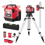
- 360-Degree Rotating Scan: Self-leveling rotary laser level for efficient site-wide leveling and alignment. ±5° self-leveling with manual mode. Variable speeds (0/60/120/300/600 rpm) and scan angles (0°,10°,45°,90°,180°) cover every task
- 1650 ft Working Distance: The laser level reaches up to 1650 ft with the receiver, ideal for large remodels and small jobsites. Includes receiver, grade rod, tripod, and laser glasses to enhance visibility in bright conditions
- Rechargeable Power: Driven by four 1.2V NiMH cells, the rotary laser runs 8–12 hours per charge (charger included), keeping you productive without frequent battery swaps
- IP54 Durability: Rugged, impact-resistant housing seals out water and dirt for long-term reliability. The rotary laser level kit comes with a tough hard case for organized transport
- Effortless to Use: Intuitive interface plus remote control (up to 65 ft) for quick setup. 5/8 inch mounting thread fits most tripods and accessories used with rotary lasers
- Earthwork quantities and soil movement can materially affect budgets.
- Design-versus-built deviations may be expensive if discovered after grading or utility work.
- Acquisition teams need early feasibility and constraint information before buying land.
- Distributed developers, civil contractors, engineers and builders need a shared visual record.
- Frequent site intelligence can reduce dependence on manual measurements and occasional field visits, according to TraceAir.
TraceAir is therefore pursuing the information layer between land acquisition, civil/site work and vertical construction. The strategic bet is broader than aerial photography: a persistent data record that supports decisions from evaluating a parcel through delivering lots and managing construction.
What the Series B is intended to fund
TraceAir said the capital would support new products and the rollout of predictive-analytics capabilities across land-development and homebuilding workflows. The company specifically described expansion into land acquisition, planning and construction management, with more automation and data-driven decisions.
Rank #4

- 【High Precision Measurement】:Our laser level delivers professional ±1mm/5m accuracy, ensuring precise alignment for tiling, picture hanging, furniture assembly and construction tasks. The high-visibility laser line is clearly visible in both dim and bright environments, ensuring accurate measurements and reducing errors - perfect for professional and DIY projects.
- 【360° Seamless Coverage】: 4x360 laser level is Class II certified that compliant with international safety standards. This laser level 360 self leveling features a unique rotating laser shield—simply rotate it to extend laser beams without tedious repositioning! With one touch, it projects 16 horizontal (H) & vertical (V) bright green lines, covering walls, floors and ceilings simultaneously for full-room seamless coverage. Remote control operation is also supported, offering convenience and flexibility in various project environments.
- 【Self-leveling, Manual Dual & Outdoor Pulse Mode】: This laser level supports fast self-leveling within ±3°—it triggers a flash and beep to remind you that it is not level. . Switch effortlessly between auto-leveling and manual modes with a simple long press of the mode switch, While the manual mode allows projection on tilted surfaces, enhancing versatility. Equipped with a pulse mode, this laser level 360 self leveling maintains clear visibility in bright outdoor conditions and it extends the working range up to 164ft, perfectly suited for outdoor construction, gardening and large-scale projects.
- 【Long-lasting Power Supply 】Powered by 2×3600mAh high-performance rechargeable batteries, this laser level 360 self leveling provides up to 12 hours of continuous operation. The swappable battery design allows instant replacement for non-stop work, while the Type-C charging port enables fast and convenient recharging. This lazer leveler tool gives you a reliable and continuous operation for demanding jobsite and home renovation tasks without frequent interruptions.
- 【Upgrade longer Tripod & Magnetic Mount】The laser level features a tripod and a magnetic mount. The 2026 newest upgraded tripod extends up to 59 inches tall, providing stable and adjustable positioning for a variety of working heights. For higher mounting positions, it can be secured with a metal plate and magnetic mount for flexible placement on walls and metal surfaces, ensuring stable use in both indoor and outdoor jobsite conditions. The laser level with tripod is compatible with standard 1/4"-20 tripods, It's ideal for construction, home renovation and all indoor/outdoor projects
Those are announced uses of proceeds, not proof that every capability is already generally available or that predictive models have demonstrated independent accuracy. The company’s statement is available in its financing announcement.
What’s actually slowing this PC down?
Pick the symptom - the matching free tool is one click away.
Customer reach and traction claims
In the 2024 funding announcement, TraceAir said it served the top 30 homebuilders across more than 40 states and Canada, and named D.R. Horton, Howard Hughes and Lennar among its customers or users. Its current website makes a different claim: that it is trusted by 18 of the top 20 U.S. builders.
Best Value

- 【Outdoor Use with Receiver】This DOVOH H3 Laser Level Kit equipped with a high-performance laser level receiver, ensuring accurate signal detection and enhanced visibility even under direct sunlight, making it ideal for outdoor projects. The working range 400ft refers to the operational range when used with the receiver, and not to the visible range of the laser beam.
- 【3 Times Output Power】This Outdoor Laser Level 360 Self Leveling utilizes high-power laser diodes to project brighter green beams, delivering an output power 3 times greater than that of common laser levels. A powerful laser beam will extend the range when working with the receiver. Please note it is hard to see the laser beam directly in the sunlight , the best approach is to pair it with the receiver.
- 【Practical Outdoor Accessories】DOVOH H3 Laser Level includes a target plate and green glasses to help you spot the laser beam outdoors. A grade rod is not included in this kit but is available separately at the DOVOH store, bundle and save.
- 【Double Shockproof Assembly】The DOVOH H3 Construction Laser Level features a unique double shockproof design, with the core assembly wrapped in two layers of cushioning rubber to absorb shocks and ensure durability. This robust construction enhances the tool's longevity and reliability, making it ideal for tough job site conditions.
- 【Dual High Capacity Batteries】DOVOH H3 Outside Laser Level comes with dual 2600mAh batteries, providing extended operational time and reducing the need for frequent recharging, ensuring uninterrupted performance on long projects.
These figures are company claims made at different times and are not directly comparable or independently audited. Customer logos do not, by themselves, establish contract size, current usage, retention or revenue. TraceAir has also publicized large-scale use cases, including a January 2026 description of the 5,230-acre Placer Vineyards project planned for more than 14,000 homes; the acreage and home count are claims in that project announcement.
How TraceAir compares with adjacent platforms
| Platform | Where it fits | Important distinction |
|---|---|---|
| TraceAir | Land development and homebuilding site intelligence, earthwork, progress and collaboration | Narrower, land-focused positioning with a turnkey drone-to-analysis workflow |
| DroneDeploy | Aerial mapping, progress documentation, design overlays, volumes and cut/fill across construction and other industries | Broader reality-capture market and integrations with systems such as Procore, Autodesk and Esri; see its civil-construction offering |
| Procore | Broad construction management, financial, document, quality, safety and field workflows | Procore announced an agreement to acquire DroneDeploy, but that announcement does not prove a completed transaction or fully integrated product; see Procore’s announcement |
DroneDeploy’s current pricing page directs buyers to request a custom quote. An older indexed page displayed annual-billing tiers of $149, $329 and $599 per month, but those figures may be obsolete and should not be treated as current without confirmation. TraceAir does not publish standard pricing in the reviewed materials; buyers should expect a sales-led quote.
What remains unknown
- TraceAir’s valuation and investor ownership percentages.
- Revenue, growth rate, retention and profitability.
- Independent benchmarks for the claimed scan accuracy.
- Whether predictive-analytics products are generally available, in pilot, or still under development.
- Standard pricing, implementation fees, data-retention charges and export costs.
- The status and product scope of any Procore–DroneDeploy integration.
Questions a prospective customer should ask
- Who performs drone flights, and can the customer provide its own data?
- What accuracy is guaranteed, under which conditions and against what benchmark?
- Are raw imagery, orthomosaics, point clouds, terrain models and CAD/GIS exports included?
- How are cut-and-fill calculations checked against the approved design surface?
- Can users compare multiple design revisions and preserve an audit history?
- What are the charges for projects, acreage, scan frequency, users, storage and exports?
- Which integrations and APIs are native?
- How are weather, airspace restrictions and inaccessible sites handled?
- Does the product supplement, rather than replace, licensed surveying, engineering judgment, staking or legal ALTA work?
Why the financing matters
The round is significant because it signals investor interest in software built around the economics of land development, where grading, soil movement, utilities and lot delivery can determine project outcomes before a home is constructed. TraceAir is attempting to make site data a continuous operating layer for developers and builders, rather than an occasional aerial report or a generic project-management database.
Quick Recap
Product prices and availability are accurate as of the date/time indicated and are subject to change. Any price and availability information displayed on Amazon at the time of purchase will apply.



